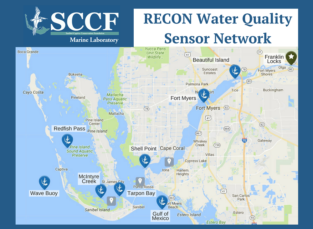
RECON Water Quality Sensor Network
SCCF’s RECON Water Quality Sensor Network: Providing Real-Time Data For 10 Years.

June Rainfall Nearly Double District-wide Average
Water Conservation Areas received more than twice their monthly average rainfall, leading SFWMD, DEP and USACE to take measures to address high water emergency.
As of June 12, the Sanibel-Captiva Conservation Foundation Marine Laboratory’s RECON Water Quality Sensor Network has been in place for 10 years.
Click To Donate To SCCF
“[I]n response to deteriorating water quality, the Marine Lab launched RECON (the River, Estuary and Coastal Observing Network). For the first time, RECON provided a real-time data network to oversee the water management of Lake Okeechobee (4,400 square miles) and the extensive watershed (1,400 square miles) affecting the water surrounding Sanibel and Captiva.
RECON allows us to understand the dynamic and changing conditions in the Caloosahatchee and our estuary. Too much water from Lake O and the watershed brings dark water and excess nutrients which cause algal blooms; too little water causes higher-than-normal river salinity levels.
- Right now, RECON is showing us — in real time — what is happening in the Caloosahatchee: RECON’s real-time chlorophyll monitoring allows us to “see” phytoplankton blooms before they are visible in the water, alerting us to collect water samples for identification of potentially harmful species.
- The recent rain contributed to hypoxia (low oxygen) near the Fort Myers RECON sensor. The fresh water sits on top of the higher-salinity river water and lack of mixing of the layers results in hypoxia in the lower layer. Oxygen levels lower than 3 mg./liter stress more than half the species living near the river bottom, including clams, fish larvae, and zooplankton. On June 5th, oxygen levels dropped below 3; on June 6th wave churning brought them back up again.
- Back in 2008, RECON allowed us to track the impact of heavy rains from Tropical Storm Fay, which raised levels in Lake O by 40 inches in 17 days. RECON tracked both the salinity drop and the movement of chlorophyll (indicating algae) downriver.

Captiva Island Septic Systems, SCCF 2011 Captiva Water Quality Assessment Report.
In addition,
- RECON data is widely used by the scientific community, water managers, policymakers and elected officials. It is a key component of the weekly Caloosahatchee Condition Report.
- The data provided by RECON’s 24/7 monitoring is available to everyone, with over 760,000 web page views. Over the course of the last 10 years, Marine Lab scientists have captured 14 million data points from the RECON sensors. That is an unprecedented achievement for water quality in Southwest Florida.
Since their launch in 2007, RECON sensors have been sentinels in eight locations along 34 linear miles down the Caloosahatchee, through the Pine Island Sound estuary, and all the way to the Gulf of Mexico. Thanks to the Marine Lab’s rigorous and attentive maintenance program, the RECON sensors have enjoyed greater than anticipated longevity.
To help us continue the maintenance of the RECON sensor network and the delivery of this essential water quality information, please consider making a tax-deductible contribution to celebrate the 10th anniversary of RECON’s launching.”