
Corps Of Engineers Begins Lake Okeechobee Discharges To St. Lucie Estuary.
The U.S. Army Corps of Engineers Jacksonville District began low-level discharges last Friday, Jan. 16, to the St. Lucie Estuary as part of the effort to manage water levels in Lake Okeechobee.
“The target flow to the St. Lucie will be 300 cubic feet per second (cfs) as measured at St. Lucie Lock & Dam (S-80) near Stuart. The target flow to the Caloosahatchee Estuary remains unchanged at 1,500 cubic feet per second (cfs) as measured at W.P. Franklin Lock (S-79) near Fort Myers. Flows at one or both locations could occasionally be exceeded by runoff from rain that accumulates in the Caloosahatchee or St. Lucie basins—those flows will be allowed to pass through structures as necessary.

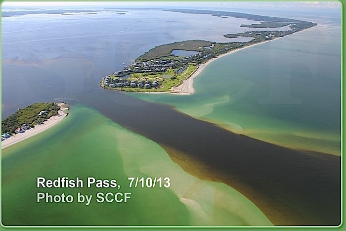
Redfish Pass, 7-10-13, Photo Credit – SCCF, Courtesy Of Ding Darling Wildlife Society.
‘We are concerned about the current lake level and forecasts calling for above-average precipitation during the remainder of the dry season,’ said Lt. Col. Tom Greco, Jacksonville District Deputy Commander for South Florida. ‘The lake is currently at the same level as in January 2013, when an early start to the wet season required us to make large-volume discharges later in the summer. Our intent is to make small releases now to reduce the likelihood of larger releases later.’
Today, the lake stage is 15.03 feet. It is currently in the Operational Low Sub-Band as defined by the 2008 Lake Okeechobee Regulation Schedule (LORS). Under current conditions, LORS authorizes the Corps to discharge up to 3,000 cfs to the Caloosahatchee and up to 1,170 cfs to the St. Lucie.
In order to prepare for increased inflows that occur with the wet season, the Corps prefers the lake level to be at about 12.5 feet at the beginning of June. The Corps will monitor rainfall and lake levels throughout the next five months, and adjust flows appropriately to ensure the lake reaches desired levels by June. If dryer than expected conditions prevail and the lake levels permit, the Corps will curtail the flows to St. Lucie Estuary.
‘We have worked with the South Florida Water Management District to move as much water south as possible since the dry season began in November,” said Greco. “We will take every opportunity to minimize the impacts. However, at the same time, we must manage the lake now with public safety paramount as we anticipate wetter conditions.’
Sanibel & Captiva and the the coastal communities of Lee County worry about freshwater discharges from Lake Okeechobee and the Caloosahatchee watershed next summer, during the rainy season. During the summer of 2013, a dark-colored freshwater plume blanketed Lee County’s beaches.

Sanibel Red Tide Photo, Sanibel & Captiva Islands, 2013.
These discharges occurred as a direct result of inadequate water storage within the Kissimmee, Lake Okeechobee and Caloosahatchee watersheds and the ability to convey water south into Everglades National Park and Florida Bay. There is also some indication that fessh water releases may contribute to red tide blooms. For more information, please see Caloosahatchee Watershed Regional Water Management Issues.
For a historical overview and perspective, please see 2005 Caloosahatchee Water Quality Assessment Report.
For more information on water level and flows data for Lake Okeechobee, visit the Corps’ water management page at the Jacksonville District website.