Sanibel Red Tide Status, November 14, 2014.
No significant red tide issues. The fishing guides aren’t reporting any evidence of red tide inshore at this time.
Here’s today’s FWC update.
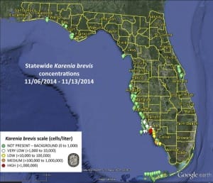
“A bloom of the Florida red tide organism, Karenia brevis, continues in southwest Florida.Karenia brevis has been detected in background to high concentrations along and offshore of southern Lee County south through Collier County, with the highest concentrations detected offshore of Bonita and Barefoot beaches. Karenia brevis concentrations range from background to very low in the Pine Island Sound system (Lee County). In addition, one sample collected offshore of Sarasota County and one sample collected inshore of Gulf County (northwest Florida), each contained background concentrations of K. brevis. Other samples collected throughout Florida this week did not contain K. brevis.
Recent satellite images from the Optical Oceanography Laboratory at the University of South Florida show that the bloom extends approximately 60 miles alongshore and up to 35 miles offshore, depending on location, between southern Lee and northern Monroe counties.
Forecasts by the USF-FWC Collaboration for Prediction of Red Tides (CPR), a partnership between the University of South Florida’s College of Marine Science and the Florida Fish & Wildlife Conservation Commission, project little net movement of the bloom alongshore of Lee, Collier, and northern Monroe counties over the next three days. In contrast, offshore surface waters in the bloom region are projected to move south and further offshore, and offshore bottom waters are projected to move slightly southeast over the next 3 days. ”
For more information, please see FWC.


